


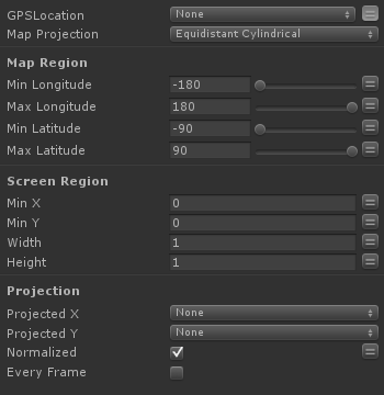
Projects the location found with Get Location Info to a 2d map using common projections.
GPSLocation
Location vector in degrees longitude and latitude. Typically returned by the Get Location Info action.
Map Projection
The projection used by the map.
Min Longitude
The minimum Longitude shown on the map.
Max Longitude
The maximum Longitude show on the map.
Min Latitude
The minimum Latitude shown on the map.
Max Latitude
The maximum Latitude shown on the map.
Min X
The screen coordinate of the left edge of the map image.
Min Y
The screen coordinate of the top edge of the map image.
Width
The width of the map image in screen coordinates.
Height
The height of the map in screen coordinates.
Projected X
Store the projected X coordinate in a Float Variable. Use this to display a marker on the map.
Projected Y
Store the projected Y coordinate in a Float Variable. Use this to display a marker on the map.
Normalized
If true all coordinates in this action are normalized (0-1); otherwise coordinates are in pixels.
Every Frame
Repeat every frame.